Project Number:
DATCP 2020-3
Other Project Number:
WR19R003
Funding Year:
2020
Contract Period:
Funding Source:
UWS, DATCP
Investigator(s) and affiliations:
Susan K. Swanson, Beloit College;
J. Elmo Rawling III, Wisconsin Geological and Natural History Survey
Abstract:
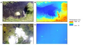
 The objectives of this study is to apply aerial thermal imaging to three groundwater issues in Wisconsin using a small unmanned aerial vehicle (sUAV) and a thermal camera. These include: 1) Determine depth to shallow bedrock over the Silurian dolomite in eastern Wisconsin at the field scale quickly, accurately and cost effectively, 2) Locate springs discharging to lakes and characterize temperature conditions in springs discharging to streams, and 3) Identify areas on Lake Michigan bluffs where groundwater discharge might lead to slope failure.
Conclusions/Implications/Recommendations
Although the soil temperature measurements alone will not accurately predict bedrock depth, they do provide a screening tool that can guide other measurements that together can provide accurate bedrock depths. The sUAV mounted thermal camera will likely have other uses for agriculture such as irrigation scheduling and determining best planting times. The camera, gimbal, and sUAV used in this study are readily available at a cost of less than $10,000.
The sUAV mounted optical camera may be a simpler and more effective way to identify limoncrenes where the springs displace organic matter and as long as water clarity is high. This work shows that the ground based thermal camera can be used to characterize temperature conditions in rheocrenes. Inverse relationships between log spring flux and water temperature summary statistics suggest that spring flux, which is more easily measured, may also be a useful predictor of the spatial distribution of temperature in fracture and seepage filtration springs in Wisconsin.
The sUAV mounted camera is a relatively inexpensive option to further investigate how spatial and temporal variation of groundwater discharge influence bluff failure in the Great Lakes.
