Pumped from the vast layers of bedrock beneath our feet, groundwater is the source of drinking water for two-thirds of people living in Wisconsin. According to geochemist Matt Ginder-Vogel, what’s in that water is largely influenced by what’s in the rock.
“Groundwater is not a lake underneath the ground. It’s water that’s in tiny pore spaces in the rock,” said Ginder-Vogel, an associate professor in the UW–Madison Department of Civil and Environmental Engineering. “So, it really interacts with the rocks around it.”
Under the right conditions, this interaction can cause naturally occurring or “geogenic” contaminants—like radium, arsenic, uranium and manganese—to leach from bedrock into groundwater.
Just where geogenic contamination is occurring in the state and how are the questions Ginder-Vogel and his team of graduate students are hoping to answer in new research funded by the University of Wisconsin Water Resources Institute.
Savannah Finley and Juliet Ramey-Lariviere are both graduate students working on the project. They’re digging through drinking water quality data from the Wisconsin Department of Natural Resources to identify municipal wells with high levels of contaminants. The goal is to provide a snapshot of geogenic contamination across the state so that folks know what’s in their water.
“We want to give a health progress report of our overall aquifer and say—here’s what we have. Here are the contaminants that we’re looking at,” said Finley.


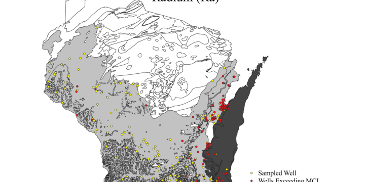
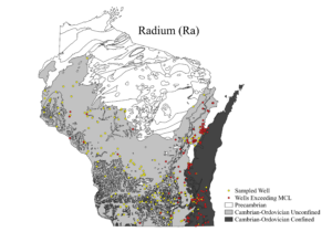
She and Ramey-Lariviere are working on a map that will show contaminant hotspots and the underlying bedrock in those locations to determine if there is a relationship between the two.
“The hope is, once we have this data, to lay it all out on top of one another and look at the different bedrock formations and hopefully try to tie in the bedrock formation with the different contaminants that we’re seeing,” said Finley.
The team is focused on public wells in the Midwestern Cambrian Ordovician Aquifer System, a horseshoe-shaped region that roughly occupies the southern two-thirds of Wisconsin. Once wells are identified, they’ll collect both water and rock samples and begin experiments in the lab, which will reveal the amount of contamination leaching from the samples and how fast it’s occurring.
“We’ll be taking rock sections and grinding them up and looking to see what comes off the rocks,” said Ginder-Vogel. “You expose them to water and see what partitions into the water. Then you can manipulate the conditions of water to release other contaminants.”
The team will then use these findings to create a model that identifies hotspots around the state prone to geogenic contamination. Ginder-Vogel hopes the model will raise awareness of the problem even if water utilities aren’t currently experiencing issues. Concentrations of naturally occurring contaminants can change over time. Take, for example, the city of Waukesha.
“[Waukesha] didn’t always have troubles with radium. But when they started pumping more groundwater—and the Chicago suburbs were also pumping more groundwater and were changing the flow path of the water—[Waukesha] started to have more and more trouble with radium,” said Ginder-Vogel.
“Once you’ve seen that, you can’t help but ask, is it happening with other things, other naturally occurring contaminants like arsenic?”
Ginder-Vogel said increased water use is what’s driving the changing concentrations. Pumping more water pulls groundwater through the aquifer in different ways and allows water to interact with bedrock it hadn’t before, picking up new contaminants.
“People who think about groundwater often think about it being this unchanging pool beneath the ground, but with all the water that we use and the way we move water around right now, there’s the possibility for lots of change,” he said.
Unfortunately for water utilities dealing with high levels of geogenic contaminants, the solution isn’t an easy or cheap one. Geogenic contaminants don’t biodegrade or go away. “They’re metals,” said Ginder-Vogel. “You can’t destroy them and remediate them. You can only move them from one place to another.”
One solution is to install treatment systems that remove contaminants from drinking water. It’s an expensive option, however, and small municipalities may not have the resources to support such an endeavor. Water utilities may also choose to rebuild a well in such a way that it avoids rock formations with high amounts of contaminants.
Ginder-Vogel’s hope is that the team’s research helps municipalities develop a plan before geogenic contamination becomes a problem. While they can’t change the bedrock, they can be strategic about how they pump water.
Said Ginder-Vogel, “We’re trying to be smart about our water resources.”

