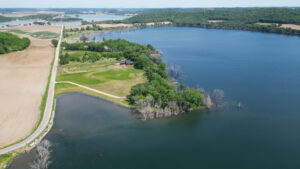
Researcher Steve Loheide spent much of his childhood on the banks of Crystal, Fish and Mud lakes in northern Dane County, Wisconsin. “I used to ride my bike between Fish Lake and Mud Lake. And they’re now one lake – they’re combined,” says Loheide.
Water levels in Crystal, Fish and Mud lakes have fluctuated drastically for at least a century. In his office, Loheide keeps a copy of a 1914 newspaper clipping titled “Crystal Lake, dried up, again filling with water.” According to the article, Crystal Lake dried up in the early 1900s and farmers started growing crops on the former lake bottom. But by 1914, water was starting to return.
Today, the lake is overflowing its banks, causing destruction of homes, businesses and crop land. During Loheide’s lifetime, he has witnessed a 17 foot increase in the water level in Fish Lake. This experience inspired Loheide, now an ecohydrology professor at UW-Madison’s Department of Civil and Environmental Engineering, to embark on a research project to understand why groundwater flooding is plaguing these lakes and what we can do about it.

“Groundwater flooding is perhaps a little bit more insidious” than surface water flooding, Loheide said. The groundwater flooding at these internally drained basin lakes is caused by a slowly rising water table. What is causing the water table to rise? Loheide and his collaborators professor emeritus Ken Potter and Ph.D. student Eric Kastelic ask that question in their project Biomanipulation of Groundwater Flooding, funded by the Wisconsin Water Resources Institute.
According to Kastelic, groundwater flooding in the area is likely due to multiple factors, like changes in both precipitation and land use over the last 100 years. “This part of Wisconsin used to predominately be tallgrass prairie and oak savanna,” said Kastelic. A century ago, settlers transitioned the landscape to shallow-rooted row crop agriculture.
Loheide and Kastelic hypothesize that this transition from deep-rooted to shallow-rooted plants, paired with climate change, has affected the water table. As part of the project, the team will be documenting the changing water table and creating a model to study the feedbacks between land use change and climate change in hydrologic systems. “We want to model this system and determine if we had more trees on the landscape, would we see less groundwater flooding?” says Loheide.
The research team hopes the data can help communities, like those surrounding Crystal, Fish and Mud lakes, build resilient landscapes. If the research shows that large-scale tree plantings could be a viable solution to groundwater flooding in internally drained basins, Loheide could see this being explored as a strategy to help vulnerable communities.

![Could trees prevent groundwater flooding? [New video]](https://www.wri.wisc.edu/wp-content/uploads/News-thumb-720x360.png)


